

Top 5 Mountain Bike Trails in Bend Oregon As An Enduro Rider (So Far…)
Bend Oregon is a mountain bike mecca and for good reason. But enduro mountain bike riding may not be your first thought when you think of Bend, Oregon however. The trails in and around Bend are more or less Cross Country trails. But, if you know where to look, you can find some seriously fun rides to scratch that enduro itch WITHOUT driving away from the amazing city of Bend! Keep reading below to get insider tips on your next amazing Bend, Oregon mountain bike getaway! Let’s get into it!
Why Visit Bend?
Bend Oregon is an incredible place to visit any time of year. There is outdoor adventure to be had of all sorts literally all year long. But as a mountain biker, you will want to visit late spring through fall for the best riding. If visiting in the Summer, you can float down the Deschutes River to cool off before heading back into town for a post ride brew and some food. Scroll to the bottom of this article for my recommendations! Bend has done a phenomenal job making the entire town ultra bike friendly, so feel free to leave the car parked and just pedal around town. It’s a beautiful city to explore with tons to see! The Hayden Homes Amphitheater is just off the river as well and hosts some amazing artists such as The Lumineers and Mumford And Sons.
If I had to sum up why you should visit Bend Oregon as a mountain biker in one sentence, here is how it would go. “Ride world class singletrack by day and sip award winning craft beers by night. Bend, Oregon is the ultimate playground for mountain bikers who love great brews.” Alright alright. It’s 2 sentences. It’s just that good though…
Before You Ride!
Bend sits at a slightly higher elevation at 3,600 feet (1,100 meters) and, for the most part, that elevation only starts to climb as you head out to the mountain bike trails. This means that snow fall exists at some of the higher elevation trails into the early summer months. It is important to understand and check trail conditions if you will be visiting during a period of possible snowfall because of this. I recommend using the TrailForks links below, COGWILD, or Bend Trails to do so. In the Summer, pop up thunderstorms are also common, so either plan to get an early start or keep an eye on the weather at minimum.
The “So Far” in the title? Bend is constantly expanding its trails and reworking older trails. This means there are always fresh trails to ride somewhere in Bend! The trail associations here really are doing an exceptional job! Please be sure to go give Central Oregon Trail Alliance (COTA) some serious love!
First off, Mount Bachelor Downhill Park is an obvious choice for someone looking for a lot of downhill, big jumps, and lots of tech. It alone is worth your mountain bike adventure to Bend. You can also do a load of different shuttle rides through COGWILD if that’s your cup of tea. But for the sake of this article, I am going to pretend you’re on the hunt for a more classic enduro ride. What do I mean by that exactly? We are talking about a huff and puff pedal to the top that makes you regret said decision, followed by a snack of course, followed by a fun downhill experience full of hooting and hollering, topped off with the phrase “Wow, that was sick let’s do it again!”.
The list below highlights trails that a beginner or expert alike will have a blast riding! Nothing here is ultra steep or technical, but these trails will absolutely scratch that enduro itch and leave you with a massive grin!
The Top 5 Enduro Trails:
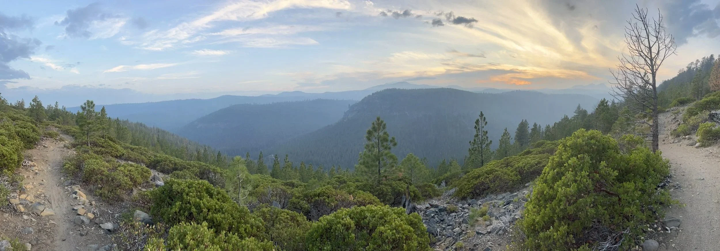
EPIC view from Farewell! Still some smoke in the air from recent wildfires.
Farewell- TrailForks Link
WATCH ON YOUTUBE!
a. Trail Details: Rated as a black diamond on TrailForks, this is one of the steeper and looser descents in the area and my personal favorite on this list. TrailForks shows this as a climb trail, it is really 2 directional but nearly everyone uses it as a descent. Just keep in mind someone MIGHT be climbing it. Expect some neat rock rolls, rock gardens, and a few spots with a fair amount of exposure. The start of the trail will be a bit flatter and a bit boring to be frank, but about .5 miles in is when you start to encounter all the goodness on this trail. The trail will end with some steep tight switchbacks on loose, shaley rock to make for an interesting trail feature! A true beginner may find sections on this trail intimidating and difficult. I would say an intermediate rider and above will really enjoy this ride. You have truly INCREDIBLE views along the trail of the valley and surrounding peaks. The climb up boasts some epic waterfalls as you follow the river nearly the entire way up. BE SURE TO CHECK FOR RECENT UPDATES ON TRAILFORKS IF RIDING EARLY SUMMER OR EARLIER. GETS LOTS OF SNOWFALL. CAN ALSO CHECK WITH COGWILD FOR TRAIL INFO.
b. Parking: You will encounter a bumpy gravel road to access this trail. Nothing that should scare you off. 4x4 is NOT required. The road will end in a parking lot. It gets very busy early nearly every day of the week. It is shared with hikers and trail runners. If the lot is full, there is ample roadside parking below the parking lot. You will need a wilderness permit to park in the area. If you do not already have the Northwest Forest Pass, there is a sign you will pass about halfway down the gravel road you can pick a pass up at.
c. Toilets: There are 2 pit toilets located in the parking lot at the trailhead.
d. Route Recommendation: Total Distance of 10 miles with 1500 feet ascent. Start your climb on The North Fork Trail and enjoy some neat waterfalls along the way. This will start steep and punchy, mellow out, and have a fairly easy grade most of the way but with some rocks and roots to spice things up. It is a shared trail with hikers, but they will thin out after passing the second waterfall viewpoint. Turn right onto Metolius-Windigo Trail (towards Happy Valley). Turn right onto Mrazek. This will take you to the start of Farewell. Overall, climbing is pretty easy with a few challenging sections and is exceptionally beautiful.
South Fork Trail- TrailForks Link
WATCH ON YOUTUBE!
a. Trail Details: Rated as a black diamond on TrailForks but rides much closer to a blue. Fun drops that aren’t too big mixed with some neat rock and root gardens. Dirt is a bit tackier than most of the trails in Bend. Bend tends to be rather sandy. Definitely a high-speed trail that will put a grin on your face. Nothing super crazy aside from a log bridge that acts as a skinny (that is fairly wide) across the creek. It is a 2-way trail, however. Not sure if there are people actually climbing it, but just keep in mind that there MIGHT be someone climbing it. BE SURE TO CHECK FOR RECENT UPDATES ON TRAILFORKS IF RIDING EARLY SUMMER OR EARLIER. GETS LOTS OF SNOWFALL. CAN ALSO CHECK WITH COGWILD FOR TRAIL INFO.
b. Parking: Park at the Skyliner Sno-Park. There is limited space but just down the road there is ample road side parking.
c. Toilets: Pit toilet located at parking lot.
d. Route Recommendation: Total Distance of 13.3 miles with 1900 feet ascent. Start the climb via Tumalo Ridge Trail. Climb is pretty easy with a couple tight, rocky, challenging sections. This trail will provide some epic views of the surrounding peaks and valley from the opposite side of Farewell, so be sure to take it all in! Connect onto the Tumalo Ridge fire access road (will look more like single track at the start of the road). The road will end at the Swede Ridge Snow Shelter (Good place to rest and eat a snack or escape inclement weather). The snow shelters out here are an amazing addition to the trails! Hop onto the Swede Ridge trail. Still easy with one notable steep section and a couple short fun downhills. Turn right onto Swampy lakes (East)until you reach the start of South Fork Trail. Turn right onto Tumalo Creek Trail and follow it back to parking lot. If you want more miles, add the Farewell loop before taking Tumalo Creek Trail or the gravel road back to the car!
Tiddlywinks (Lower)- TrailForks Link
WATCH ON YOUTUBE!
a. Trail Details: Rated as a blue on TrailForks, I think this is an accurate rating. This is a fantastically fun trail. We are talking big smiles here! This is a fantastic trail to self-shuttle if you have got a group you are riding with. There are some fun rock drops/ rolls, mix of table and small “gap” jumps, nice berms, and just a bit of chunk thrown in. Definitely be mindful of your speed on the jumps. This is a VERY High-speed trail and if you aren’t ready, you can really launch off these jumps. Also worth noting is a super short side trail called Tiddlywinks Upper (DH Option). This is an insanely fun chunk of trail with some neat rock drops and rolls on some loamy dirt. Absolutely worth a couple laps prior to starting your descent on Lower Tiddlywinks. Overall, Lower Tiddlywinks is broken up into a couple sections. You have a fun DH, then a bit of a flat pedally section, another fun DH, pedally section, and then a downhill pedal mixture into the parking lot. Lastly, this is technically a 2-way trail (honestly not sure why it is though, it really shouldn’t be in my honest opinion due to the high-speed descenders). So just be mindful there MIGHT be someone climbing the trail.
b. Parking: Park at the Storm King parking Lot
c. Toilets: No toilets available in parking lot.
d. Route Recommendation: Total Distance of 10 miles with 1500 feet ascent. Start on Storm King (South) heading towards Funner. At the intersection, hop on Funner and follow signs to remain on the Funner “Climb” trail marked by signs (this section of Funner is 2 way so be mindful of people descending). At the road intersection, turn left and follow the wide road all the way to the Tiddlywinks (Upper) intersection and go left. Follow the trail a short bit until you reach the Tiddlywinks (Lower) intersection. Hit the Upper downhill option a couple times then descend Tiddlywinks Lower. It will end by intersecting Funner and Storm King (South) with a fun rock roll. Follow Storm King (South) back to the parking lot. Head back up for a Funner lap if wanting more miles!
Funner- TrailForks Link
a. Trail Details: Rated as a blue on TrailForks with some black diamond splits. I think this is an accurate rating. This is a super fun trail that boasts loads of neat drops and rock rolls with plenty of gnarly rock gardens in between. The top of the trail will be a pedally downhill that is open and sandy. After a short while you will start encountering some rock gardens, but the grade will still be fairly flat. Once you reach the bermy section you pedaled up, the downhill adventure begins. This trail is not very steep, but it is definitely a blast and there is plenty of cool features to session along the way. At the top of the trail there is a fun skills area with different jumps and drops you should definitely mess around on. This trail will get pretty sandy in the summer. Again, be cautious of uphill traffic on this trail. There is a climbing specific trail for some of it, but other sections are 2 directional.
b. Parking: Park at the Storm King parking Lot
c. Toilets: No toilets available in parking lot.
d. Route Recommendation: Total Distance of 10 miles with 1165 feet ascent. Start on Storm King (South) heading towards Funner. At the intersection, hop on Funner and follow signs to remain on the Funner “Climb” trail marked by signs (this section of Funner is 2 way so be mindful of people descending). You will eventually come to an intersection with the dedicated Funner Climb Trail that you must use to continue climbing. It will eventually merge back to the standard Funner trail for a very short bit until you have the option to hop on a side dirt road called Big Spring Road. Use this road to climb to the top of Funner. The Wanoga Shelter is at the top of the trail. It is a great place to rest. eat some snacks , and also has pit toilets available. Follow Funner all the way back down. The black split options can be quite challenging but are really neat and fun! Hope on Storm King (South) to head back to parking lot. This is another easy shuttle trail if you have multiple cars going as you can get dropped off at the Wanoga lot and just hop on the trail. Head back up for a Lower Tiddlywinks lap if wanting more miles!
Whoops (Upper and Lower)/ Upper Phil’s Trail- TrailForks Links
WATCH THIS YOUTUBE VIDEO FOR UPPER/ LOWER WHOOPS
WATCH THIS YOUTUBE VIDEO FOR UPPER PHIL’S!
a. Trail Details: SO this one I could break up into 2 separate rides to be honest, but the climb is so easy that we rarely just do one or the other. It is for this reason that I have it listed like this. Whoops is rated as blue and Upper Phil’s is rated as a Black diamond. I think Upper Whoops is absolutely a green and Lower Whoops as a blue is fair. Upper Phil’s I think is more of a blue to maybe a spicy blue at most. There is 1 feature on Upper Phil’s, near the start, that I understand why they would give it a black diamond rating. Upper Whoops is a very smooth and easy ride. No features what so over. A couple roots near the end and a few spots you could bump jump. Otherwise, it is just a fun, smooth, relaxing, fast descent through the trees that has an excellent view of the surrounding mountains from the top. The Shooting Star Snow Shelter is at the top and makes a good rest and snack break or place to escape inclement weather. Lower Whoops is a very fast and flowy descent as well. However, it has loads of berms and jumps. The jumps are all tables ranging in size, but a few have a bigger takeoff off on the side that turn them into a double if you want. There is also 1 optional gap jump. Fantastic freaking trail! Upper Phil’s is the most challenging segment on the Phil’s loop. Nothing is particularly challenging or scary apart from 1 rock garden that gets narrow near the start. Otherwise, this is a fast chunky trail. You will have the initial descent followed by a short climb and then another descent all the way to the road. It is a blast and a go to evening ride for me!
b. Parking: Park at the bottom of Lower Whoops in this lot.
c. Toilets: No toilets available.
d. Route Recommendation: Total Distance of 12 miles with 1195 feet ascent. These totals and following route are assuming you are doing Upper to Lower Whoops to Upper Phil’s. Climb up the 310 Road. You will pass the Lower Whoops and Upper Phil’s trail heads but keep going on the road. At the “T” intersection go right on the Upper Whoops Access Road. This road plus some signage will take you to the top of Upper Whoops. Follow Upper Whoops down. Cross the road and enter Lower Whoops and follow down. Take same climbing road (road 310) back up to do Upper Phil’s. You will first need to hop on Phil’s/ Storm King Access Trail to get to the actual start of Upper Phil’s. Follow Upper Phil’s to the second road crossing. At this road go left and it will take you straight back to your car.
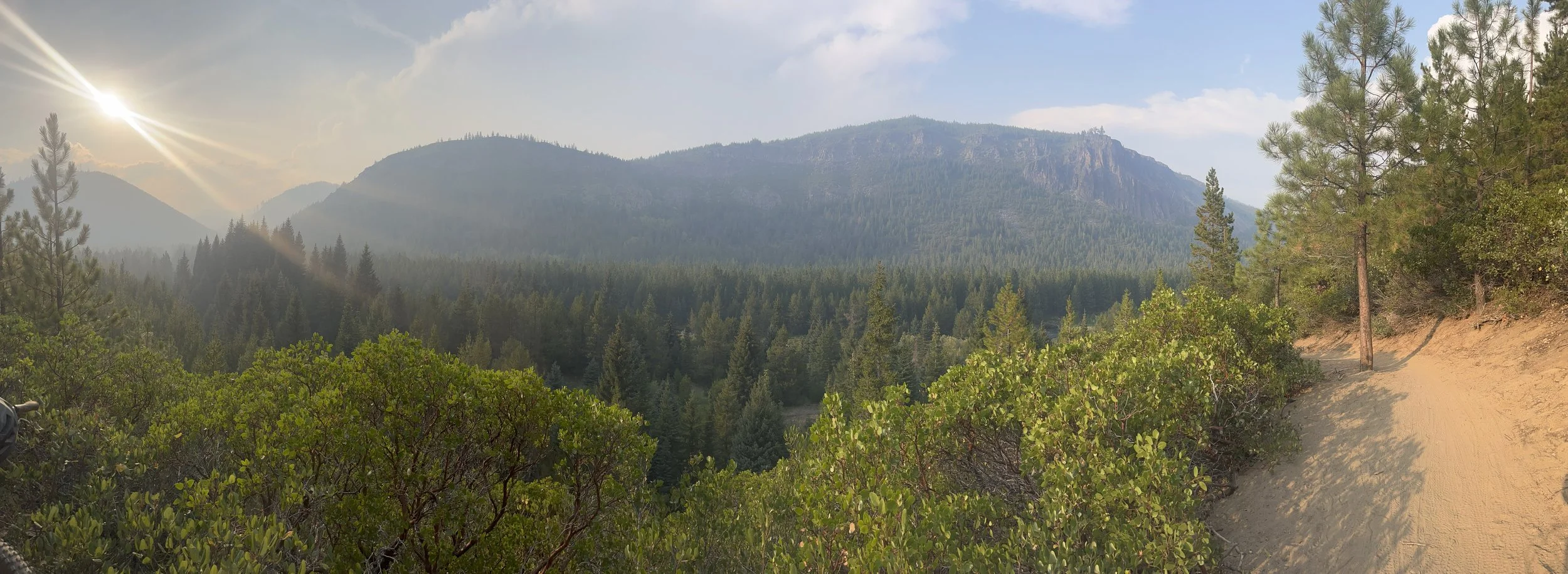
EPIC view from the South Fork Route! Still some smoke in the air from recent wildfires.


Post Adventure Brews And Food:
No adventure or ride is complete without some excellent food and ice cold beverage to wash it down! Here are my 3 favorites food plus beer locations!
Monkless Belgian Ales- Amazing beer is an understatement! The atmosphere is also really fun an inviting. They serve incredible food as well that is very filling. I do recommend their Bavarian Pretzel. It’s literally the best pretzel I have ever had!
Miyagi Ramen- Incredibly delicious and filling bowls of Ramen. They have some meat skewers that are to die for as well (especially the beef). They serve Asian beers in cans that I personally think are great after a day of riding since they tend to be a lighter crisper beer such as Singha. But, if that isn’t your thing, this is quite literally across the street from Monkless Belgian Ales to grab a brew!
The Podski- This is a unique and fun spot and a location that makes Bend famous! Its effectively a collection of food trucks surrounding a seating area. There is everything from authentic Thai food to sushi to Italian to vegan food. Something for everyone here. There is even a bar that serves lots of local beers on draught in some tall mugs!
Best part about all these? They are are located next to each other so its easy to grab food at one, beer at another, and dessert at the last! There really are countless good options, these are my current favorites however!
If you want to stay up to date with the BEST information to build your next adventure or you just want to see more of my adventures and photography, follow along on Instagram @martins_migration or subscribe to the newsletter below, and subscribe to my YouTube Channel!
Check Out The Gear I’m Using!


Check Out More Articles You Might Enjoy!
This past week on The Migration has been CRAZY! It all started with Claire attempting features on a mountain bike trail we rode last June that she didn’t even consider possible at the time. Then I attempted to summit Mount Bachelor for the first time on snowshoes and ski back down. To top things off, Spoke and I head deep into the woods down a dirt road and cook an Outdoors Boys inspired dinner. Check out the video to see how it all turned out! It was an absolute blast of a week and going to be a great video!